William Balchin, a distinguished Professor of Geography, died on 30th July, 2007, aged 91, and will be sadly missed in many quarters. He had two great devotions during his life – family and Geography, and was superbly successful in relation to both. He was a Hampshire man, born and bred in Aldershot, with many long summers spent with his grandparents in Cornwall. His childhood was happy but as an only child, he early decided that he wanted a larger family of his own. He was only 17 when he met and fell in love with his Yorkshire wife, Lily Kettlewood, but she was four years older and thought of him as just a friend of her kid brother? However, his achievements over the next few years caused the age gap to shrink into insignificance and they were married when he was 23. They remained devoted to each other until Lily’s death in 1999, just a few months before their diamond wedding anniversary.
They had three children, Peter, Joan and Anne, but sadly Joan, a mathematician, died at the age of 43, when she was Assistant Registrar at Leeds University. Peter followed in his father’s footsteps to become a geographer and taught at Leeds Metropolitan University, as also did his lawyer wife, Daphne. Both are now retired and their children, Claire and David, are completing their university careers. Anne, a solicitor in a building company, was able to spend time with her father in the weeks before he died.
William was the joint Founder of the Balchin Family Society, so his early aspiration for a larger family achieved an enormous boost during his retirement years. As well as being President of the Society in which he might be seen as a figurehead, he did a great deal as Newsletter Editor.
William had an exceptionally able mind and while still in primary school was promoted a year ahead of his age, transferring early to the High School. There he was put into the fast stream so by the time of General and Higher Schools examinations he was two years below the normal age of candidates. The school had not previously offered Higher Schools Geography so it was quite a pioneering effort to equip himself for this subject, and then to pass wjth distinction.
He needed a scholarship to go to Southampton University, which meant taking a separate County Major examination. The scholarship was not awarded, so in deep disappointment, he prepared to leave school. To get him to stay on, as an unprecedented third-year sixth-former and head boy, his headmaster had to reveal events behind the scenes. William had actually come top of the County list but the university grant was withheld because he was only 15 at the time. The extra year opened up the opportunity to go to Cambridge, with a State Scholarship as well as a County Major grant.
At that time Geography was a subject considered to have integrated breadth rather than specialist depth, and all his life he tried to apply this principle, moving from one aspect to another and in many cases laying new foundations for others to take up. This began with the dissertation required during his first summer vacation at Cambridge. A Frenchman, Henri Baulig, had aroused a great deal of interest by arguing that sea level had formerly been much higher and had cut a series of level shorelines as it fell, step by step. William decided to test this idea in Cornwall by seeking to identify any such steps and mapping their exact positions. He established that they did indeed exist, at levels up to about 1000 feet. This was the year that the Royal Geographical Society first offered its annual prize for a student essay, so William wrote his dissertation twice, in 10,000 words for Cambridge and at half length for the prize essay. As a piece of original research it outclassed all the other entries and was published in the Geographical Journal while he was still only 18.
He then cooperated in scientific research by the Cambridge staff and after graduating, just before his 20th birthday, he was appointed to the junior academic post of demonstrator. During the summer of 1938 he joined one of the last Arctic expeditions to set off into the unknown, completely incommunicado. As the team sailed up Billefjord, 600 miles from the North Pole in Spitsbergen, he spotted something that enabled him to test another contemporary speculation. This was ‘isostasy’, the idea that the immense weight of ice during the Great Ice Age had depressed the land beneath it and squeezed out, southward, some of the plastic layer at depth – the ‘sima’. As the ice melted and its front retreated, the sima would gradually ooze back, raising the land surface again.
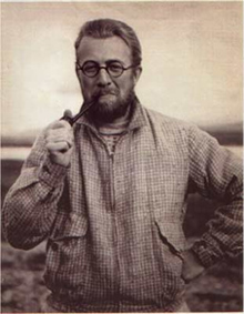
William recognised that such uplift would lack the stable intervals needed to cut wide beach platforms like those in Cornwall but he noticed some much more quickly formed features – shingle ridges, sometimes the product of a single storm. The further from the ice front at the head of Billefjord, the more the returning sima would have had time to lift the land and the ridges, so that while they were only at sea level at the glacier foot, southward from there they would be found over range of levels fanning up to their highest in the south. William had taken a course in Geodetic and Topographic Survey and was professionally skilled, so he set out to map a 50 mile length of coast, camping out when it became too far to return to base each day. A luxuriant beard helped protect him against the Arctic temperatures.
His map proved the point. Isostatic uplift had raised the most southerly tip of the fjord coast by nearly 300 feet, with shingle ridges all the way down below it. Back home, people found this discovery incredible but the Norwegian government incorporated his high quality surveys into the official maps and retained the place names given by the team. William was commemorated by ‘Mount Balchin’, now ‘Balchinfjellet’, a 5000 ft glaciated peak at 81° north latitude.
When World War II was declared William had a post that enabled him to support a wife. In October he started making marine charts in the Hydrographic Department of the Admiralty, evacuated to Bath, and was due to marry Lily in December. But all leave was cancelled because of the war and a wedding did not rank as an exception. Fortunately the naval officer further up the chain of command found a permissible alternative. ‘Domestic affliction’, he said. ‘Marriage is domestic affliction.’ But as William said, his marriage never was.
Besides making marine charts, including those for the D-Day invasion of France, William also helped devise special air maps with scales suited to aircraft speeds and colours that maximized legibility in cockpit lighting. Near the end of the war William and his Cambridge/ Spitsbergen friend, Norman Pye, launched a new research field: local climate. Bath occupied a 500 ft cleft of the River Avon, and they related cause (weather measurements) to effect (first flowering dates of various plants) at different heights up the valley sides. The schools recorded Stevenson-Screen figures and local botanists noted flowering dates. No Stevenson screens were available In wartime so William and Norman made their own, first fighting to obtain a licence to buy 1000 feet of timber. The research findings were interesting and local climate studies were taken up by others. It was one of William’s students, Tony Chandler, whose painstaking work established the local climate condition known as the urban heat island.
In 1945 William became a lecturer at King’s College London and mapped erosion surfaces on Exmoor for his Ph.D. He realised that university mapwork lacked the professionalism of the Hydrographic Department and devised a splendid first year course to introduce it. Academics were still publishing sketch maps so he spoke on the subject at an Institute of British Geographers meeting. He enumerated specific amateurisms and illustrated them with examples from published papers. Shock waves went through the audience as people recognised their own work on the screen, but William was so kindly and encouraging that he generated enthusiasm, not antipathy. He laid the foundations for a revolutionary upgrading of mapwork in Britain and abroad and would not publish his talk as he did not want to put people’s defects on record.
William and Norman Pye enlarged their geographical horizons by studying rock-desert landforms in the Mohave and Sonora deserts in USA, but it took until 1952 to overcome all the obstacles, including the ban on converting sterling to dollars. Again they brought speculations down to earth through precise survey.
In England William tackled the quite different field of landscape evolution W G Hoskins had seen that history has left visible landscape legacies and envisaged a county series on the subject. William produced the first volume on his beloved Cornwall, an excellent starter area because its historical imprints range right across the millennia from prehistoric ages to moderp tourism. Once again he made a new concept precisely explicit, and his work was heavily quarried by Hoskins in the later national volume.
When the King’s College Department expanded to four staff, the new appointment was Alice Coleman, who shared William’s concern with geographical breadth. Like Norman Pye, she became a lifelong friend, and cooperated on several pieces of research after he had been appointed as a Professor to head a new Geography Department at University College Swansea. One field of endeavour was a venture into the limestone terrain of the Mendip Hills, where they found various lines of evidence that certain landscape features, often assumed to result from solution of the rock by rainwater, were actuality due to collapses into underground caverns.
A quite different initiative followed the adoption of the word ‘numeracy’ in parallel with literacy, to overcome the casual way some people almost boasted of being poor at arithmetic. It was claimed that being innumerate was as bad as being illiterate, and it seemed that a comparable word was needed to cover geographical skills such as map-reading and drawing and landscape interpretation. William and Alice coined the term ‘graphicacy’ and when he was President of the Geographical Association, he chose speakers on this subject for the Presidential day, beginning with his own address. He created a warm welcome for the concept, which was taken in the art world also and potentially included engineering. At the time of the National Curriculum, graphicacy was considered an important element for Geography and Rex Walford has recently written that the graphicacy concept ‘… will always remain a defining landmark in the history of geographical education and those articles you [both] wrote about it in the 60s are still regularly quoted today in geographical magazines.’
After Alice Coleman launched the Second Land Utilisation Survey in 1960, William acted as its Treasurer and also participated as a leader when she chartered aircraft for teachers’ field tours in N. America, the West Indies and Africa, before travel agents had thought beyond Europe.
Swansea gave William enormous scope for making a mark. He converted Geography from being just a subsection of Geology with only two staff to becoming virtually the largest department with some 600 undergraduates. Money was freely available to create the country’s first brand-new Geography Department in a Natural Science building. Novel features were three practical laboratories, to give each year’s students a community ‘home’ between lectures and library work. Another innovation was a physical laboratory for scientific observation of the work of waves and running water. His design plans were requested by no fewer than 45 universities where new departments were projected, both in Britain and abroad, so this was yet another way in which he had a wide influence.
Soon after reaching Swansea there were water shortages and Welsh patriots urged that the English should pay for the Welsh water going down the Severn. The English replied ‘Fine, and well charge you for all the flood damage your water causes.’ William wrote thoughtful papers for water engineers, etc., suggesting solutions that included a Water Council for Wales. This Council was duly set up and a geographer was to serve on it. He naturally hoped to be the one, but a Welshmen was chosen instead. William good-naturedly thought this a nice joke. He was extremely talented administratively. He avoided having rumours running around by sending all staff simultaneous notes about any prospective event and before each term he circulated what came to be called ‘Billy Balchin’s hymn sheets’ – a page to each one setting out their exact responsibilities for the coming period. For students he kept superb notice-boards, pasting every appropriate job advertisement on large coloured sheets.
While Vice-Principal for five years he found that the Principal received complaints from staff in every department except two – the smallest in the College and Geography. His staff trusted him implicitly and would always go to him direct. Once, for example, there was just a single promotion available and four staff who could reasonably hope for it, but they said they would not put in applications as they would leave it to him to decide. And the intensity of his hard work was such that when he ceased to be Vice-Principal he was replaced by three people.
At the autumn social in 1977 he said that new students often told him that he had taught their parents but that year one had revealed that he had taught his grandfather, so it seemed time to retire. And when he did retire in 1978, they produced a book in his honour, which was not the usual excuse for publishing their own papers but a collection of his own important breakthroughs, many of which they had tracked down in non-geographical periodicals.
Each later year he went back for College and Departmental occasions. When he was 90, he wanted to give a last party but they had beaten him to it by already arranging a birthday celebration for him. Staff who had retired kept in touch through a monthly lunch club and some who had left Swansea returned for his 90th birthday. Many others hearing about it asked to be included and twice as many people attended than was originally planned. They said what a happy Department it had been when he was in charge.
He and Lily retired to her home county of Yorkshire, to the lovely little town of llkley, not far from Leeds where two of their children were working. He continued his work for Geography, supporting the various organizations. In the Royal Geographical Society he won the distinction of serving on the Council for 17 years. Thirteen of these were as Chairman of the Education Committee, when each year he arranged for speakers on a range of careers for geographers to speak to packed audiences of sixth-formers, and as the careers were different every year, the accompanying teachers also found these occasions fascinating. In retirement he helped frame the lecture programme of the Society’s branch in York.
He was also a keen supporter of the Geographical Association. During his years at King’s College he was the organizer of its annual conference, and he was a Trustee for many years. In Yorkshire he joined the committee of the GA’s Bradford Branch.
William always had a great sense of perspective, both looking ahead to the future and relating it to the past. For example, he was well ahead in his recognition of impending anniversaries, such as the 150th of the Royal Geographical Society where he outlined a schedule of celebrations that was closely adhered to in the event. He also wrote a the history of the Geographical Association on the occasion of its centenary and edited a book on the 75 years of the Joint School of Geography – a saga of cooperation between King’s College and the London School of Economics.
For the Royal Geographical Society he prepared an archive of all the geographers who contributed to the success of World War II, with some intriguing revelations. For example, it was a geographer, J F N Green, who cracked the Italian code, using his meteorological knowledge to identify and interpret their weather bulletins. This feat must have been just as impressive as the well-known non-geographical cracking of the German code, but unfortunately it was never written up in similar detail.
William, like his family predecessor Admiral Sir John, was characterized by modesty. He was motivated to achieve the good of the family and of his chosen subject and not to secure personal recognition. This, combined with the fact that he moved between different aspects of the subject meant that he did not become as well known to the public as certain specialists, while his publications in many different journals meant that people were often surprised to learn that he had produced an unusually large number of papers. Nevertheless, his wide-ranging contributions were a vital element in helping the young university subject of Geography to become mature.
William Balchin was born June 20 ,1916. He died on July 30, 2007, aged 91
For more information on William Balchin’s life click on the following link: https://en.wikipedia.org/wiki/William_Balchin